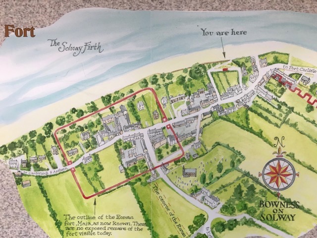
It’s a tonic when a younger generation inspire you to share an adventure with them. In our case it’s 13 and 10 year old grandchildren who want to do the 84 mile long Hadrian’s Wall National Trail. Happily for all concerned we’ve been gradually doing it in sections, in no particular order, as and when. As we inhabit the eastern half it’s something of an adventure to roam west, on beyond Carlisle, to the official start/end of the coast-to-coast trail at Bowness-on-Solway. This was where the port and fortress of Maia stood, guarding the estuary and marking the western end of the Wall.
It’s a very British thing to promote a world heritage site like Hadrian’s Wall and then provide no public visitor facilities at its western end. Luckily for us, after a long car journey and traffic jams in Carlisle, we could negotiate a trip to the loo for everyone at the commercially run visitor centre that dominates the village centre. (B&B, bar, bistro, apartments & luxury gym) For either a donation or a purchase access to the toilets is granted. We were told by one of the locals that there used to be public toilets in the village until recently but they closed because the local authority could not afford to maintain or clean them.
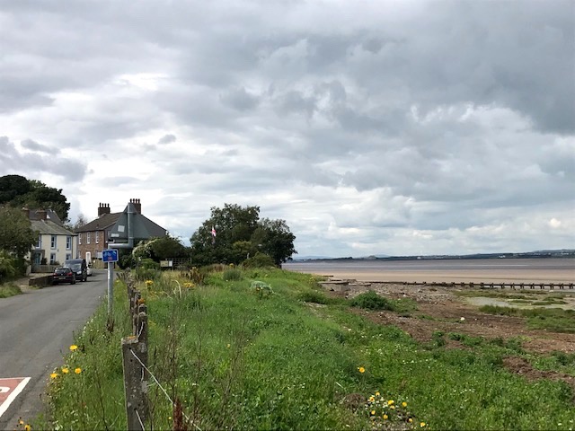
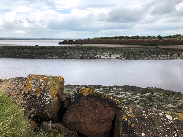
A sign on the wall of a ginnel (alleyway) off the narrow through road gives access to an open bankside with a wonderful view over the estuary of the River Eden to Scotland. Crossings on the ‘wath’ pathways have been made here for centuries by those knowledgeable or desperate enough to brave the shifting sands at low tide. Early Christian saints spreading the gospel, invading medieval armies or marauding bands of Reivers all have their place in the history of the Solway. From 1869 when it opened to 1934 when it was demolished, a mile long railway viaduct physically connected both shores. Now all you see are the pier head remains on either bank.

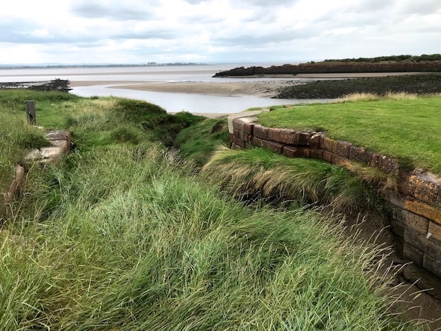
The local community have created a delightful space here to give an encouraging send off (or welcome) to walkers on the official long distance trail. A wooden framed pavilion, floor mosaic, artist designed bench, information board and a secular blessing ‘ Good Luck Go With You’ carved into the apex.
Setting off on the trail via the only road in or out I noticed a long straight length of large sandstone blocks below a thick hawthorn hedge marking the field’s edge. A reminder that a single track branch line once ran along here and a stone embankment was needed to front high tidal ingress. The Solway Junction Railway closed to goods traffic in 1899 and was finally done away with in 1932.
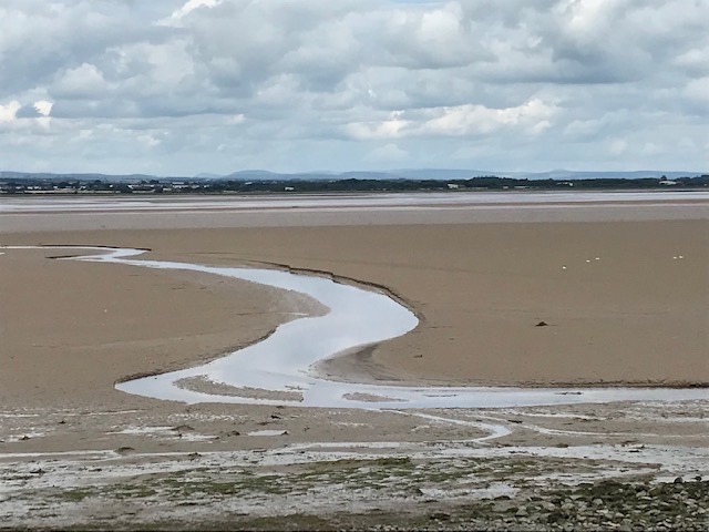
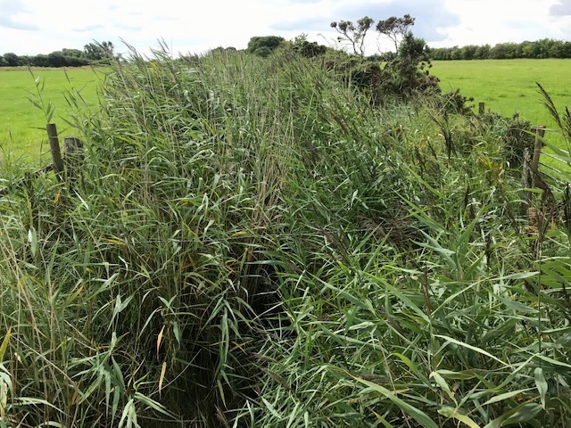
A stream we crossed spilled out on the seaward side, through grass covered settled mud banks above the tide line, carving a final course through the sands. On the other side of the road its hidden bed between grass pastures was characterised by dense high reeds merging into the hedge lines. It must provide a good hiding place and highway for wildlife.
The initial mile of road walking brought us to Port Carlisle. It’s a fascinating settlement whose very existence is a testimony to the rapid changes brought about by the industrial revolution. Before the coming of the railways Carlisle’s growth as a regional centre at the lowest bridging point on the River Eden depended on it having a port outlet. This was the driver in transforming the tiny fishing hamlet of Fishers Cross into the new settlement of Port Carlisle in the 1820’s by digging an 11.5 mile canal from sea to city centre. Designed by the Newcastle based engineer William Chapman it was cut deep and wide in order to take smaller seagoing vessels.
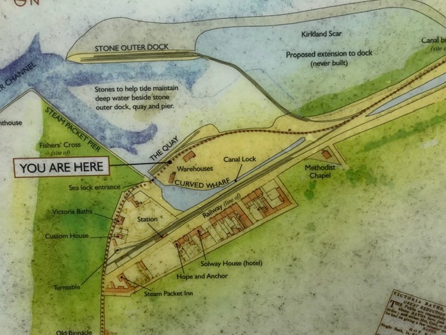
The purpose built harbour and canal basin facilitated turn around and storage and could also accommodate larger vessels so cargoes either way could be transferred. Passengers soon followed coal and grain as the main freight with boats sailing to Whitehaven, Liverpool and the Isle of Man.

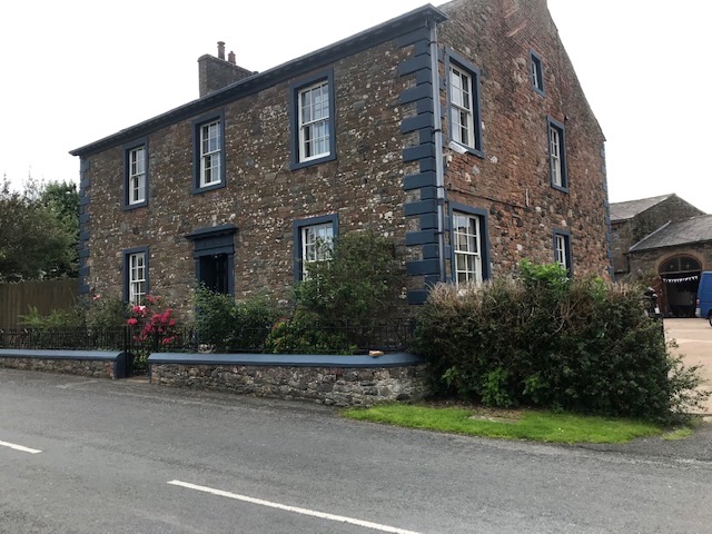
Hot and cold sea bathing facilities opened and all the new settlements brick built houses and merchants provided services of one kind or another for visitors as the Victorian era dawned. Many north America immigrants passed this way. Most famously the Carlisle born mother of Woodrow Wilson who would become the 28th US President (1913-1921). The former hotel where her family and many other migrants stayed overnight awaiting passage is now a private house. (Below)
Within three decades inland waterways – as a means of travel communication and commerce – were overtaken by the arrival of the railways. By the early 1850’s Port Carlisle canal had been filled in and replaced by a branch of what would become a new line from Carlisle to Silloth further down the Cumbrian coast. That town rapidly developed as a deep water anchorage so Port Carlisle’s fortunes declined, its infrastructure silted up and fell into disuse.
Talking about this history with the kids, we had our picnic just off the path, perched on dislocated blocks of red sandstone that once made up the massive canal and quayside wall, overlooking the abandoned headland and harbour. A quiet peaceful spot now, with oystercatchers nearby and other wading birds too far off to identify with any certainty. The Solway is the third largest continuous intertidal habitat in the UK and home to many thousands of migratory birds in winter. So at least one migratory tradition continues on this esturial shore.
I left the family to continue following the trail and wandered back to Bowness to pick up the car where we’d left it at the RSPB reserve. I then drove to meet them on the green at Glasson, opposite the recently closed village pub, now being converted into a private dwelling. The hostelry was called ‘The Highland Laddie’, a reference to the clansmen of the 1715 and 1745 Jacobite uprisings, who would have crossed the estuary here on the ancient wath ways.
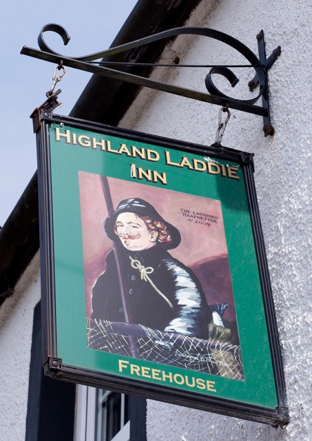
Whether caused by the Covid crisis or something else the pub’s demise is a sad loss to walkers (open all day, every day) beer lovers (CAMRA branch met there) and local fishermen. The tradition of haaf netting for salmon survives here and the pub’s former sign board (2009) humorously reflected both the art of pub signage and the practice of sustainable small-scale fishing. (I’ve been fortunate in the past to see this ancient netting technique in action on the Lune at Sunderland Point and the Tamar at Cotehele, between the Cornish and Devon banks.)

England’s fearsome warrior king Edward I, known as ‘the Hammer of the Scots’ died of dysentery while on campaign at Burgh-by-Sands on June 7th 1307. A dying wish for his body to be taken into battle at the head of the invading host was quietly ignored by his successors and the late king was solemnly processed back to London for burial in Westminster Abbey. I couldn’t resist stopping here briefly on the way home to see the parish church of St Michael where the king’s body lay in state.
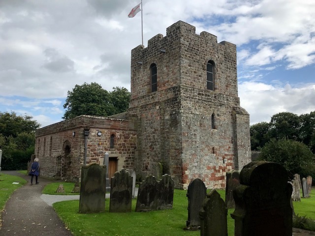
There’s an excellent display about the event in the church tower whose ground floor you enter through massive thick walls by a narrow passage gateway known in the dialect as a ‘yett’. Like most religious and secular buildings in these parts St Michael’s was constructed of dressed stone taken from the Roman wall fort of Aballava on which Burgh is situated. (Named from the Old English ‘Burh’, meaning fortified settlement) Like the Roman fort of Maia (modern day Bowness) there’s virtually no sign it ever existed today, so widespread and thorough has been the recycling process!

Edward I’s imperial expansionist campaigns in Scotland and Wales had a huge effect on cross border life. The long-term instability left isolated communities to fend for themselves against cross border raids. In Burgh’s case the church’s defensive western tower, dating from 1361, gave clear views over the Solway, its bells warned villagers of attack whilst the nave sheltered their livestock. At one time there was also a defensive tower at the other (eastern) end, which explains why there is no window behind the altar. This is the region’s best example of a church doubling up as a ‘bastle‘ or defensive house.
What a pleasure it is to discover places where layers of history overlap or lay half hidden and to see how geography has defined its character and development. Though shorn of Roman structures this stretch of the national trail is rich in re-formed buildings and industrial heritage as well as being an internationally important haven for wildlife.
Postscript. A friend has sent me this link. It’s an evocative account of fording the Eden and the Esk by David Livermore led by local guide Mark Messenger, starting at Burgh.
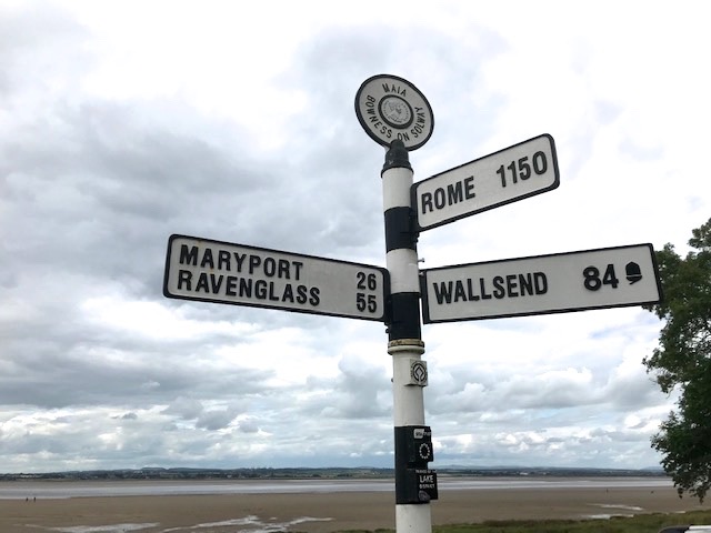

Isn’t that an utterly charming fingerpost? I understand and appreciate those pointing towards ‘New York’ or ‘Sydney’ because these were emigrant destinations, yet so many of them, for little reason, include ‘Moscow’ or ‘Tokyo’, paces which few would have travelled to. But this one has Rome and three significant Roman settlements. I wonder have they a fingerpost in Rome pointing to Maia at Bowness-on-Solway and does it say 1840 km?
>
LikeLiked by 1 person
I like your reflections Pascal…Have just updated with a postscript about a recent crossing of both the Eden and Esk which is an entertainingly compelling read! https://solwayshorewalker.co.uk/2016/07/13/crossing-the-sulewath-a-guest-post-by-david-livermore/
LikeLike